

CHICAGO GUIDE
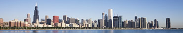
When visiting an unfamiliar city, I have often wished there would be a handy illustrated guide for photographers - one that told you where and when to go for the best views and the best light. This led me to think, why not produce a handy guide for photographers visiting my home city, Chicago? So here it is ... or at least the first piece; a description of my favorite Chicago walk, which is right in the center of the city, along the Chicago river.
If this guide is useful, or you have comments, please use my contact link to send me email. To see more of my Chicago photos follow the links in the left navigation sidebar. Reading the guide and using it to make notes to plan your visit is free, but please do not download the photos unless you buy a license (they are protected by copyright).
Have a great time in Chicago !
WALKING ALONG THE CHICAGO RIVER
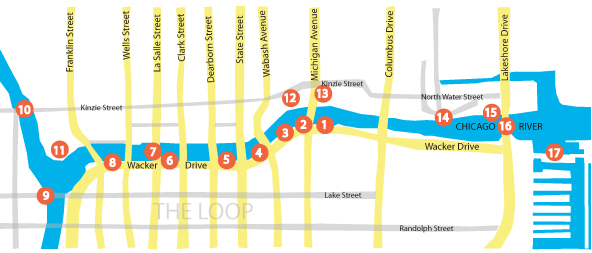
Start Point: Anywhere along the walk, but a great place to begin is photo spot 1, which is at the intersection of Michigan Avenue and Wacker Drive. Note that many buildings will be in shadow until a couple of hours after sunrise. On a sunny day the light is good for the buildings on the North bank from early morning to early afternoon.
Parking: There are many convenient places to park north and south of the river. I often use the underground parking lots off Michigan Avenue, just past The Art Institute, south of Randolph Street.
Overview: The Chicago River borders Wacker Drive, forming the northern boundary of the so called "Chicago Loop". The river used to flow eastwards, carrying all sorts of unpleasant things into Lake Michigan. Since the lake is Chicago's clean-water source, this was not good. In 1900 the engineers did their thing, and the flow was reversed. Since then the unpleasant stuff has been exported to the Mississippi. The walk shown on the map takes you along both north and south banks of the nice clean Chicago River, and then to the lakeshore. You will see spectacular architecture, beautiful bridges, and the photogenic lakefront. If you are a slow ambling shutterbug like me, allow half a day for the walk. If you like to explore side-streets, take a coffee break and have lunch, plan a full day. If it's sunny, you're in for a treat!
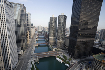
The Chicago River west of Michigan Avenue, viewed two hours after sunrise, looking west. Wacker Drive is on the left. The nearest Bridge is the State Street crossing. The two cylindrical towers are River City, and the dark skyscraper to the right is one IBM Plaza.
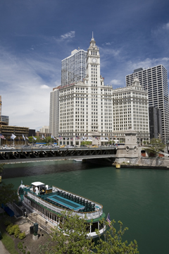
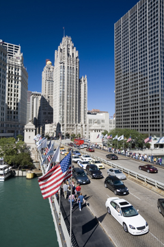
The Michigan Avenue Bridge is a good starting point. Built in 1920, this drawbridge is a double-decker with a span of 220 feet. The best view is from the south bank. To get to Photo Spot 1, walk a little way to the east along Wacker Driver, which rises well above the river. This will allow you to look down on the bridge with the Wrigley Building in the background. If you want to get closer to the river, at the bridge there are steps down to a river-level walkway that goes east to the lake. That's on our agenda for later.
The Wrigley building is one of the architectural masterpieces of Chicago. Designed by Graham, Anderson, Probst and White, construction started in 1919 and was completed in 1925. Its 450 feet accommodates 30 stories. On closer inspection the Wrigley consists of two buildings joined by a 14th floor skywalk. The beautiful white facade is made from a quarter of a million English glazed terra cotta tiles (Wow!) ... and then, topping it off, there's that great clock tower.
Noticed the boat? Boat tours leave from both east and west sides of the bridge. This is a great way to see the Chicago architecture, so if you're feeling lazy, go for it!
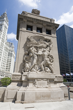
Now that you are at the Michigan Avenue Bridge, you can't possibly miss the bridgehouses. The one on the south-west side is not just a bridgehouse, it's a museum! Go down the steps next to the south-west bridgehouse, and at the bottom you will see the museum entrance. The museum opens at 10am. If you're too early, plan on coming back later in the day. You get climb the 5 floors inside the bridge tower, learn lots of facts about the river, and see the gears and the two 108 horse powered engines that lift the bridge. You can also peer through the windows at the top to get shots of the bridge from above.
Back on the outside, as you climb to the Michigan Avenue level, notice that half way up you can access a footpath on the lower deck of the bridge. This provides nice views of the river. Climbing back to the upper deck, the outside of the bridgehouse is ornately decorated with scenes depicting heroic themes. There is a plaque on the pavement that declares this to be the site of Fort Dearborn, built in 1803 and demolished in 1856.
OK we are done with the bridgehouse. Next walk west along the south river bank. Between Michigan Avenue and Wabash Avenue (the next bridge downstream), you have two options: the river-level path (down the steps again) or the high-level path (the Wacker Drive sidewalk).
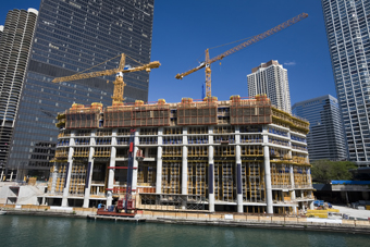
As you walk towards the Wabash Avenue Bridge, look across the river, and you will see a new skyscraper under construction: The Trump International Hotel and Tower.
The city is a dynamic place. Old buildings go and new skyscrapers rise from their ashes. Right now there are many future landmarks under construction. The Trump International Hotel and Tower is one of the most visible. Designed by Skidmore, Owings, and Merrill, construction began in 2005. To be completed in 2008, it will be the 2nd tallest skyscraper in Chicago (and America). With 92 stories and 1131 feet , this wonder is said to cost 750 million dollars. For a few million dollars you could buy one of its penthouse condominiums!
OK, you're at the Wabash Avenue Bridge. The bridgehouses here are less ornate than their Michigan Avenue neighbors, but are still photogenic.
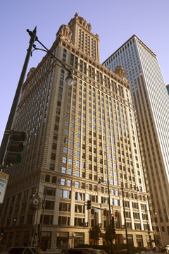
On the other side of Wacker Drive, just beyond Wabash Avenue, is another Chicago gem: The Jewelers Building, created for the city's diamond merchants. Designed by Thielbar and Furgard plus Giaver and Dinkleberg, it was completed in 1926, This 40 storey building positively glows late afternoon, as the last rays of the sun bounce off its terra cotta facade.
Back on the south bank of the river, continue to the State Street Bridge.
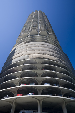
Between the State Street and Dearborn Street bridges there is a good view of some more north bank landmarks: the twin cylindrical towers of Marina City. Designed by Bertrand Goldberg Associates, these 587 feet high towers were commissioned by the International Union of Janitors (why not?), and completed in 1967. The lower levels provide car parking, and the higher levels condominiums. Walking towards the next bridge (Dearborn Street) you can get good shots of the towers by descending again to the river-level walkway. For close-up shots, partly cross the Dearborn Street Bridge. To avoid bridge vibrations, you may have to wait for a quiet period when there are no cars on the bridge.
Done with Marina City? Continue along the south bank towards the next bridge (Clark Street) and beyond..
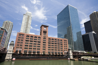
As you walk along Wacker Drive between the Clark Street and LaSalle Street bridges, look across the river. On the north bank you will see the Central Office Building. Formerly the Reid, Murdoch, and Company Building, this magnificent red-brick structure was designed by George C. Nimmons, and completed in 1914.
Notice something funny about the design? Count the windows to the left and right of the clock tower. It's not in the center! One side of the building was shortened in 1926 to allow LaSalle Street to be widened in preparation for its new bridge.
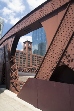
Constructed in 1928, this is one of my favorite Chicago River bridges. Designed by Edward H. Bennet, it has a span of 242 feet. The rust-colored ironwork perfectly matches the red-brick facade of the Central Office Building, and the graceful curves and attractive rivet-laden surfaces are just begging to be photographed. If only the traffic would stop shaking the deck! Of course, the shaking stops when the lights at the southern end of the bridge are on red, but then the queue of waiting cars tends to back up across the bridge spoiling the composition. With a little patience, however, you will get that perfect shot. Note that the best lighting is when the sun is on the west-facing ironwork. If it's not, it may be a little too early in the morning. Don't worry, you will get another chance later in the walk.
Ready to go on? Keeping to the south bank, and continue along Wacker Drive to the Wells Street Bridge.
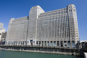
From the Wells Street Bridge you get a good view of another architectural masterpiece: Merchandise Mart. Designed by Graham, Anderson, Probst & White. When it was completed in 1931, this limestone-faced four-million square feet beauty was the largest office building in the World. You can continue getting good shots of this landmark as you walk further along the south bank, towards the Franklin Street Bridge.
This is where the river splits into its north and south branches, and Wacker Drive bends at 90 degrees to follow the south branch. Go with the flow. The first bridge around the bend, which crosses the south branch, is the Lake Street crossing.
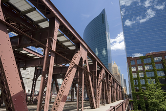
Another great spot to shoot photogenic ironwork and super architecture. This time the ironwork supports the elevated Chicago rail system, the so called "EL". If you walk over the Lake Street Bridge, just on the other side the ironwork changes from rust-red to pale-yellow. This is a good place to photograph a passing train. The trains are fairly frequent, passing every few minutes. They are silver in color, so on a sunny day you have silver trains, yellow and rust-red ironwork, blue sky, and great reflections in the background skyscraper windows.
The skyscrapers on the Wacker Drive side of the bridge are in themselves noteworthy. The one with a curved face located on the river bend is 333 Wacker Drive (see Photo Spot 10). If you want pictures with reflected buildings and clouds, this is the skyscraper for you!
If its near lunchtime you may want to take a break at this point. Wander back across the bridge, and look for a place to eat, before continuing. Overwise, stay on the west side of the river and continue along Lake Street.
From Lake Street, turn right onto North Canal Street. This will take you to the north branch of the river. As you walk along Canal Street you will cross some railway tracks. Across the tracks, on the right, there is access to the river, giving a good view of the branch-point. There is quite a lot of river traffic, so with a little luck you can get some good boat shots.
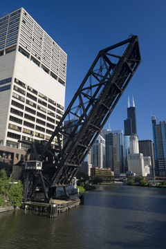
Continue along canal street, and you will come to the Kinzie Street Bridge which crosses the north branch of the river. From here you get a great view of an old railway drawbridge, which is permanently raised. From this side, the drawbridge gets the sunlight late afternoon. If the light is right, you can get good shots of the raised bridge with the Sears Tower in the distance. The white building to the left of the drawbridge is the Apparel Center, which was designed by Skidmore, Owings, and Merrill, and completed in 1977.
Now cross the Kinzie Bridge to the north bank, and walk to the right, to the base of the raised railway bridge, and beyond. From here you can get close-ups of the raised bridge. The south-facing side gets good light for a short time early afternoon. As you get to the south-west corner of the Apparel Building there are steps that take you up a few feet. At the top you can get some more shots of the south face of the bridge, from a slightly higher viewpoint.
Walk back down the steps at the south-west corner of the Apparel building. You are now on the north bank of the river at the point where it splits into its north and south branches. The path follows the river, on its north bank, heading east.
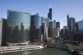
Look across the river to the south bank. The curved flashy building is 333 Wacker Drive. One of the most photogenic buildings in Chicago, this 36 storey skyscraper was designed by Kohn Pedersen Fox, and completed in 1983. The best time to photograph this great view seems to be late afternoon. However, if you leave it too late the buildings on the west bank of the southern branch will be in shadow. If you just want to focus on 333 Wacker Drive, late is great.
We are now going to head back to the Michigan Avenue Bridge, and then to the lake. Following the river on the north bank, at Franklin Bridge there are steps up to bridge level. Cross Franklin Street and walk in front of Merchandise Mart, with the river on your right. The long line of busts in front of Merchandise Mart celebrate distinguished Chicago business people. Beyond the Mart you come to Wells Street Bridge. Between Wells Street and Clark Street (two bridges upstream) there is no riverside footpath on the north bank. You can either cross to the south bank, retracing your steps along Wacker Drive, or skirt around the north side of the riverfront buildings. Whichever route you chose, you can return to walking besides the river along the north bank between Clark Street and Wabash Avenue. At this point the Trump Tower construction site cuts you off, but if you skirt around to the north side, there is a path that takes you to the Wrigley Building, giving you a good close-up view of the west face. The path goes between the two buildings of the Wrigley, under the skywalk that joins them. Now you are back at Michigan Avenue, just north of the river.
You now have another chance to visit the Bridgehouse Museum ... to do this you will need to cross the bridge and walk to the south-west corner (see Photo Spot 2).
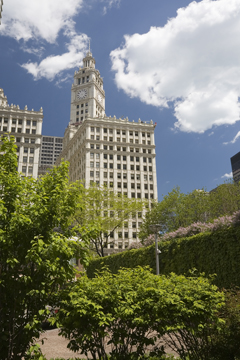
If you have already seen the museum, or want to skip it, stay north of the river, and cross Michigan Avenue. In front of you, the skyscraper that resembles a great gothic cathedral is the 34 storey Tribune Tower. Constructed between 1922 and 1925 this architectural marvel is 463 feet tall. Look carefully at the base of the tower. Incorporated into the structure are bits and pieces from all sorts of other famous buildings around the world. The plaza to the south of the Tribune Tower is, in fact, E. North Water Street, which runs parallel to the river. To the east of the plaza is the NBC Tower, and to the south, between the plaza and the river, is the Equitable Building.
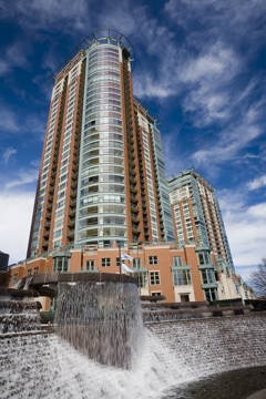
Walk east on W. North Water Street and eventually you can get back to the north bank of the river. The walk along the north bank takes you to the Centennial Fountain and two impressive condominium skyscrapers; River View I and River View II. The fountain, which is in the front of River View II, was built in 1989 to commemorate the founding of Metropolitan Water Reclamation District in 1889 (the guys responsible for reversing the flow of the river). Of the two River View buildings, I find River View II ti be the more photogenic. Designed by DeStefano and Partners, this 448 feet 32 storey skyscraper was completed 2004. The older River View I building, 27 stories high, was completed in 2000.
You can walk only a little further, beyond River View I, along the north river bank. Pause to take a look across the river Unfortunately the light for this view is best early morning, but then the light for the fountain and River View buildings is not so good. You can't win them all.
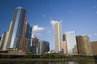
Across the river you will see The Regatta, a new skyscraper designed by DeStefano and Partners. This 45 storey condominium building is to be completed in 2006, at a cost of $140,000,000. 471 feet. To the right of The Regatta, the tallest building is the Aon Center. Completed in 1972, it is the 2nd tallest skyscraper in Chicago. It made the headlines shortly after its completion when its then-marble facade began to buckle, and was subsequently replaced, at great expense, with the present white granite one. As the river nears the lake, you can walk no further along the north river bank. Retrace your steps to the Michigan Avenue Bridge.
Back at the Michigan Avenue Bridge, if you still have some energy, the steps at the south east corner of the bridge lead down to a river-level walk. Heading east along this walk will give you good views of the north bank buildings across the river. The path continues under the Congress Drive and Lakeshore Drive bridges, to the Harbor Lock and Lake Michigan. At the harbor, some of the views are good early morning, and other views good late afternoon. After going under the Lakeshore Drive Bridge, take a short detour to the right, and up the ramp that takes you onto the lower deck of the bridge. This will give you a good view of the harbor.
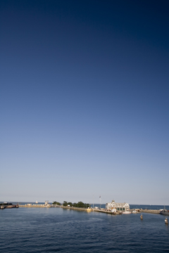
All boats passing between the river and lake Michigan pass through the Harbor Lock, which allows the river level to be maintained below that of the lake, aiding it's reversed flow. The 80 feet wide lock, completed in 1938, has length of 600 feet and a depth of 22 feet.
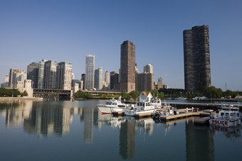
Returning down the ramp and back to the harbor, you can walk along a jetty towards the harbor wall. Various police and other official boats are moored on the left side. Behind them you see, 68 stories and 645 feet tall, Lakepoint Tower, a condominium skyscraper designed by Schipporeit-Heinrich Associates, and built in 1968. The light is good in this direction very early in the morning.